
Frenchman’s Cap, Franklin-Gordon National Park, Tasmania
- gypsy
- May 9
- 5 min read
46km, (+-) 2700m Elevation
Frenchies was on the bucket list for such a long time, and completing it in 2023 is still a memory I hold tightly. To date the views on this hike are the best I think I’ve ever seen. And the memories, oh boy, they won’t be forgotten in this lifetime either.


My best friend Sienna and myself set out to complete this on a severe weather alert (no I would not recommend others do this), but we checked the weather religiously leading up to the event and were pretty confident that we’d hit the window in between. Which we essentially did. A day earlier or later and it would’ve been a bail out experience. We got lucky.
We completed the trip in 4 days, although I know people who have done it in a day and others who have done it in 5 - it’s completely up to the walker. Although given the views, I’d recommend slowing it all down and enjoying it.
WHAT YOU SHOULD KNOW:
The drive to the West Coast of Tasmania is relatively windy, adn the weather conditions can flip in an instant. Plan to take your time. No matter where you drive from in the state, the trip will likely take you ~3 hours.
Frenchman’s Cap has a booking system. It’s free, and pretty much in place to protect the trail. Please, please, please use this system correctly.
Both huts on this trail have rainwater tanks for you to top up at.
The weather conditions on this side fo TAS flip and flop, prepare for the worst to come in at any moment. Note that in bad weather conditions the rescue chopper cannot get to you. Be safe and make smart choices that match your personal capabilities at that moment.

MY 4 DAY ITINERARY:
DAY 1.
Ok so day one is always going to be a slightly later start depending on where you are driving in from. Assuming you can start walking by midday you should be sitting pretty.
This day you are walking through grasslands, bogs, boardwalks and up a few hills with stairs/paths in between. It’s ~16km of this, and the signage suggests 5 hours. This is super achievable. But as a self proclaimed slow walker I’m fairly confident we took ~6 hours.
The hut you’ll be walking to this day is the Lake Vera Hut. It’s a pretty simple structure, sitting just off of the banks of Vera Creek. The water is cold as hell, and running. You may not want it on the way there - but on the way out it’s a hell of a great spot for a quick soak of the body and legs. The hut itself has several bunks, although there’s also tent pads available outside - we hiked in a tent intending to use it, but were the only ones at the hut so saved ourselves the effort.
Hot tip. Spend the day trying to spot frenchies along the walk. I promise you there will be many tricks.
DAY 2.
Day 2 is pretty much straight up hill. There’s a fair bit of rock scrambling so if you’re on the shorter side be prepared to climb up a few larger rocks bouldering style. It’s only 5.5 km and ~950m elevation gain, plan to take 4-6 hours depending on fitness.

The views this day are insane. You spend the first part of it walking alongside Vera Lake/Creek, through wet lands that made me think there should have been tiny fair doors at all of the tree roots. Then the party twists up, running along a large waterfall for a majority of the climb. Finally when it feels like it will never end you flatten out at Barton’s Pass. Which has the most incredible view of the lakes. Walking along Barron Pass I discovered on Day 3 was lovely, on day two however, it was not. We got caught in a blizzard. Cold, wet and only wearing tiny shorts, Sienna made the mistake of telling me she was concerned I was going to get hypothermia. My brain immediately decided she was concerned I was going to die… It’s extremely exposed and the wind absolutely rips through this area. At the end of the pass you’ll reach a final set of stairs, leading you up towards tonight’s hut.
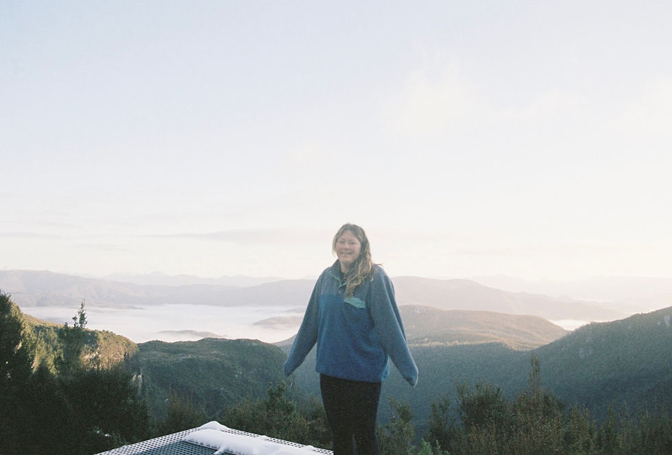
The hut tonight is arguably the best free hut in the state, Lake Tahune Hut. It has hydro powered heating (its not by any means hot, but it is enough to dry your gear and take off the biting chill), there are two toilets both with window views of the valley beneath (neither smell). And a helipad which has an incredible view.
Hot tip. Browse through the walkers log book, there are some fantastic entries from over the years.
DAY 3.
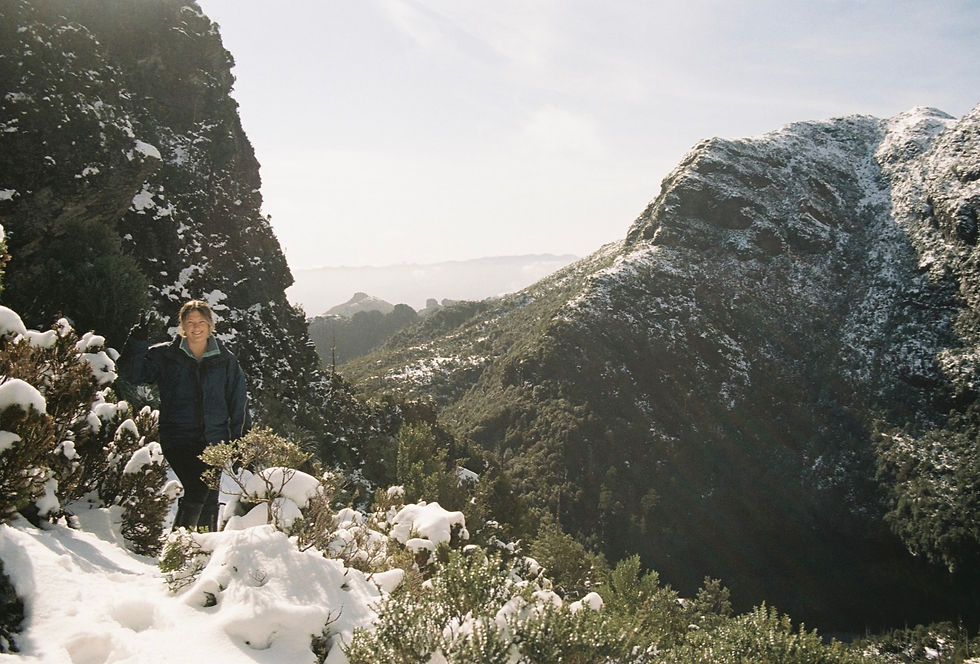
Today you attempt a summit. I say attempt because that’s all most people manage. With the area being so exposed and having such unpredictable weather conditions, it can become unsafe to summit pretty quickly. Sienna and I didn’t summit regardless of the fact it was a blue bird day, because of icy conditions. Had we stayed one more night it would’ve been perfect conditions. The walk up to the summit is 3.2km and 450m elevation gain, allow for 3 hours. We had a decent amount of snow heading up there, so it was slippery and I can’t speak for the typical trail conditions, but even a small walk up is worth it for the view of Lake Tahune.
After your summit attempt stop and enjoy the view one last time from the helipad, go for a little dip in the lake if you feel up for it and then begin the slow journey back down to Lake Vera where you’ll stay the night again.
DAY 4.
The final stroll out. It’s a relatively flat / downhill 15km back to the car park. You’ll be absolutely buzzing after the last few days. I’d recommend setting off on the earlier side of the morning, so that you can make it to the Wombat Cafe in Derwent Bridge for a celebratory burger. The staff here are always cranky and rude, but the burger quality absolutely makes up for it!
Hot tip. Where your gators and long sleeves this day. You spend a fair big of time walking beside high grass that the snakes love to lounge in. This applies for day 1 as well.


Comments